Other options of OS
Ordnance Survey
also provides personal online maps in the form of OS getamap and OS Openspace.
For personal use and entertainment, OS getamap
(www.getamap.ordnancesurveyleisure.co.uk) is the best choice.
Its main advantage compared
to the Bing is that it provides a more detailed OS maps. In addition to
Landranger 1:50.000 map, it also has Explorer series maps 1:25.000. These maps
are favored by walkers because they include more details, such as field
boundaries. To see any OS map, you firstly need to choose the Leisure button in
the upper left corner of the map.
You can view the map by
using a basic Guest account, but to have any advanced features, you will have
free registration. Then you can add markers and route maps and save your
commented map online, email it to others or export it to a handheld GPS device.
You can also import routes from the GPS receiver.
This feature is really
useful - especially if you want to use OS maps on the hills, but you do not
have suitable handsets - the ability to print maps. The registered users can
only print A5 size maps free, but if you want to print full-page map, you pay a
£1 / print or subscription for a year with £ 30. It provides the ability to
print unlimited.
You can provide a link to
the OS getamap from your site, but to embed the map you will need OS Openspace
(http://openspace.ordnancesurvey.co.uk). You will need to register to have the
API key for OS Openspace. For non-commercial use, registration is free but
commercial users pay for services. Application programming interface (API) is a
mapping of commands that you mix with HTML commands to include maps in your
site. For example, a command to draw a basic map, plus marker ... etc...
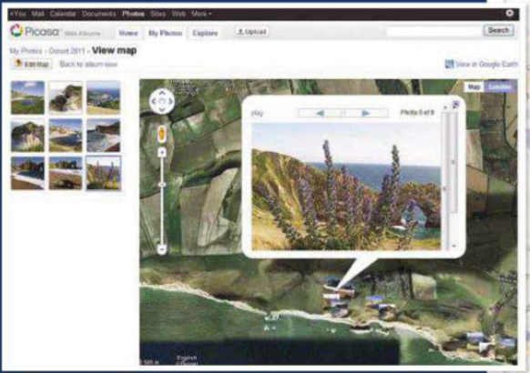
See your photos on the map
To see your
photos as thumbnails on the map and view them at full resolution, click on
where they were taken as an imaginative way to present your images. It is
also very easy to implement by using Picasa Web Albums.
Go to
http://picasaweb.google.com and register (you will need a free Google
account). Click Upload, name the album and click "Select photos from
your computer." Once you select them, click Open.
When they are all
uploaded, click "Create album map". On the map, it appears and
navigates to the area of interest and drags your photos onto the map, zoom to
the location of them correctly. Click Done and return to album overview. You
will notice a small map to the right and the option "View map",
which presents larger maps. You can share this album just like any other
albums, and you can also decide to share geographic information.
You can present your
photos in Google Earth or Maps. Click "View in Google Earth" and
then, in the dialog box, click Save As to save a KML file to disk. Opening
this file will present your data in Google Earth. As any other KML file, you
can also view it in Google Maps. Click "My Places" and "Create
Map", and you can create a map from KML file.
|
Picasa
provides everything you need to paste geography tags of your photos and view
them in Google Earth and Google Maps
If you ever studied HTML, as opposed to the
production of websites by using the website building process, you will find it
very simple. In fact, whether you have never written codes for a web page, it
is certainly not as difficult as you imagine. If you do not believe, there is
an alternative form of Map Builder helping you generate code automatically. To
see the potential of Openspace, please see "disclose a secret: embed OS
maps on the website" as below.
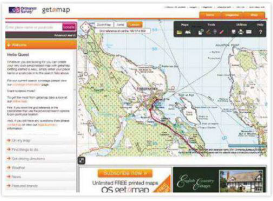
OS
getamap provides free access to the Landranger and Explorer maps, but you will
have to pay to print large maps